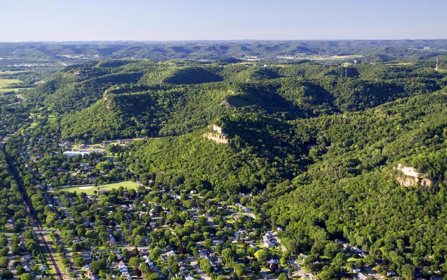
La Crosse Blufflands
In a unique and visionary partnership, Mississippi Valley Conservancy and the City of La Crosse formed the La Crosse Bluffland Protection Program to provide scenic preservation and ensure that the beauty of the City’s landscape is not destroyed by poorly-planned development. The program was created to protect rare natural communities like bluff prairies and provide a marvelous outdoor recreational resource for the public.
From 2002 to 2009, the City budgeted money each year with which the Conservancy acquired properties within the eight-mile stretch of Mississippi River bluffs that overlook the city. Funding from the City was leveraged with grants from Wisconsin's Knowles-Nelson Stewardship Fund. As a result of the La Crosse Bluffland Protection Program, the City of La Crosse was recognized as "Policymaker of the Year" by Gathering Waters, Wisconsin's land trust alliance, in 2006.
The City of La Crosse and Mississippi Valley Conservancy carry on the proud tradition of land conservation in the Coulee Region that was pioneered by Ellen Hixon and other citizens in the early 1900s who purchased Grandad Bluff and Hixon Forest and donated these gems to the city for all residents to enjoy.
City-owned properties
Nearly a thousand acres of the La Crosse Blufflands have been protected by the Conservancy, in addition to the hundreds of acres of Hixon Forest and Grandad Bluff that are also owned by the city. The largest individual tract is the Mathy Quarry (Cty Rd FA) property at 453 acres. Miller Bluff (Rim of the City Rd) and Cliffwood Bluff may be the most scenic parts protected, with their large, sheer rock faces.
The properties shown on the map below are now owned and maintained by the City of La Crosse Department of Parks, Recreation & Forestry. They are permanently protected from development and mining by Mississippi Valley Conservancy. Please call the Parks & Rec department at 608-789-7533 with questions about activities allowed/not allowed on these properties. Click for City Trail Maps or use the buttons above to download maps we've created for public use.
For information about hunting in the La Crosse Blufflands, contact the City of La Crosse Department of Parks, Recreation & Forestry at 608-789-7533. Click for City of La Crosse Hunting Areas Map.
Other protected properties in the La Crosse Blufflands
The Conservancy continues to acquire connected properties in the La Crosse Blufflands, in keeping with our goal to create corridors of native habitat for wildlife. Most recently, the Kaplan tract was purchased with funding from Wisconsin's Knowles-Nelson Stewardship Program and the Paul E. Stry Foundation. Over the years, several parcels have been donated to the Conservancy for permanent protection, including land from Barbara and Don Frank, and various parts of Cliffwood Bluff from La Crosse Floral Company and Jay Hoeschler. Some of these smaller parcels of land provide connecting access to other parts of the La Crosse Blufflands, and they all provide valuable wildlife habitat in an urban setting.
A community resource
The La Crosse Blufflands provide year-round public access to scenic beauty and outdoor recreation. The Conservancy leads many guided hikes through the La Crosse Blufflands. We also frequently take school and college groups to the bluffs for hands-on environmental learning and ecological restoration work.
All visitors are asked to help protect the fragile wildlife habitats of the La Crosse Blufflands by observing signs and policies pertaining to the each bluffland property.
882 acres (86 additional acres with easements)
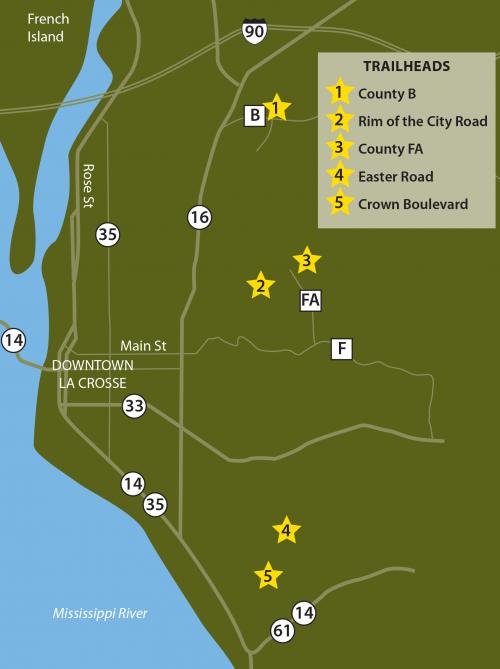
Find Nature's Treasures at each of these trails:
County Rd B Trailhead: W5845 Cty Rd B, Onalaska, WI - Follow Hwy 16 north to Cty Rd B. Turn right and follow for ½ mile just past Bethany Church. The parking area is on the right and the kiosk is the start of the trail. This is an up and back hike. At the top it becomes private land and it is marked as such. Do NOT trespass on private property.
Rim of the City Rd Trailhead (Miller Bluff): Rim of the City Road, La Crosse, WI - Go east on Main St, which becomes Bliss Rd, for 2.1 mi to CTH-FA. Turn left (north) and park in the lot at the end of County FA or at the Upper Hixon Forest lot and walk along County FA and Rim of the City Road to the trailhead. Parking is not allowed on Rim of the City Road or at the trailhead. Trail begins on other side of gate.
County Rd FA Trailhead (Mathy): N3065 Cty Rd FA, La Crosse, WI - From La Crosse: Follow Bliss Road up the bluff past Alpine Inn. Turn Left on Cty Rd FA and follow for 1.5 miles. The trailhead parking area is at end of road. (Also access the Kaplan tract through this trailhead)
Easter Rd Trailhead (Hass): Easter Road, La Crosse, WI - From the intersection of Losey Blvd. and Ward Ave, head east on Ward Ave. to 33rd Street. Turn right on 33rd street and follow south to Park Lane Drive. Turn left on Park Lane Drive and follow to Maple Drive. Turn right on Maple Drive and go one block to Easter road. Turn left on Easter road (at the fork in the road stay right) and follow to trailhead, which is about ¼ mile up road and on the right.
Crown Blvd Trailhead: From the intersection of Losey Boulevard and Ward Avenue: Head east on Ward Ave. to 33rd St. Turn right on 33rd St. and follow it south to Robinsdale Ave. Turn left on Robinsdale and follow it to Cliffside Dr. Turn right on Cliffside. After .3 mi, turn left on Crown Blvd. and park along the road near the trailhead sign, or go straight to Springbrook Way, turn right, and park along the road. Please observe street parking ordinances.